


1936 Economic and Social History
Thanks to Bob Kamman and Bob McCollum for submitting the following article to the website. It is an extract from a Dissertation submitted to The University of Chicago Faculty of the Division of the Social Sciences in Candidacy for the Degree of Master of Arts, Department of History by Hubert Scmidt in December 1936. The Dissertation was entitled: "An Economic and Social History of Bond County, Illinois before 1850; A type study of the development of a prairie-forest region in the middle-west."
PREFACE
The development of Bond County was part of the larger evolution, which by 1850 had chanced much of the Illinois country from its original wilderness state to a land of cultivated farms populated with a settled agricultural people. The history of this change, though significant in its ultimate outcome, is not startling in any of its phases, but is rather the story of a slow, and gradual, but steady growth.
The early history of Bond County was not unique or greatly different from that of many of its neighboring counties. The purpose of this study, therefore, is not so much to chronicle a series of events and occurrences as to picture so far as possible the changing scene, to portray the economic and social growth of a typical prairie-forest area.
CHAPTER I
Introduction
Geographic Features
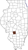
Bond County is one of the intermediate counties lying between the black-soil "corn belt" On the north and "Little Egypt" on the south and possesses some of the characteristics of each of those regions. Its boundary on the west is a little less than forty miles from the Mississippi and from St. Louis, the city which has played such an important part in its economic development. The chief land route from the East to St. Louis, the "National Trail," leads directly across the center of the county from east to west. Greenville and, later, Pocahontas and Mulberry Grove became important merchandising points for a large hinterland because they were on this artery of trade. The county contains a compact block of nine townships to which is appended a tier of fractional townships two sections wide across the north end and down the west side to the mid-point. Bond County is not large, the total area being about 378 square miles, the average for the counties of the state being 544 square miles.
In its natural state the county was a little more than one-half prairie.(1) The largest continuous prairie was in the eastern part, about four miles wide near the northeast corner and increasing in width to nearly twelve miles in the south. This region comprised more than one-fourth of the county. Its various more or less detached parts were known as Northeast Prairie, Southeast prairie, and Beaver Creek Prairie. The western side of the county was invaded along its full length to a depth of from one to four miles by the famous Looking Glass Prairie of Madison County. On the north several fingers of prairie projected down between the forested streams. Fork Prairie, the largest of these, contained over twenty sections between Shoal Creek and East Fork. There were also occasional prairies of small extent within the forests. An example was Round Prairie, which contained about three sections entirely surrounded by the heavy timber of Shoal Creek.
The prairie soils of the county varied from very thin clays to deep dark soils like those of the "corn belt." Occasional variations were the fine-grained reddish soils of some rolling land. and the gravelly land of steeper slopes.(2) Topographically there was also much variation. Some land was so low and. flat that it could not be farmed without drainage. One pioneer later wrote, "Thousands of acres were covered with water weeks and months." Nine-tenths of Township Four North, Range Two West, in the southeast corner of the county, is very flat and. much of it remained un-drained until after l850. At various places through the county flat basins retaining water the year round were known as ponds" or "lakes." Much of the prairie, on the other hand, was gently rolling and well drained.
The following excerpts from the notes of the origina1 survey illustrate variations in prairie lands as to soil and surface, though one must remember that the surveyors probably shared the generally low opinion of the prairie held by the early pioneer.
- This mile all level Prairie land-thin soil
- Middling good farming Prairie
- Wet prairie
- This mile is over rolling dry Prairie on which there are thickets of Hazels-good soil
- This mile is over smooth Prairie Soil 3rd rate.
- Land level. Prairie good soil fit for Cultivation.
- Prairie gently rolling, 2nd rate.
- This mile level wet prairie.
- Entered a small rich prairie.
The vegetation of these prairies seems to have been that of the typical Illinois prairie. One pioneer writes, "I bought a place in 1831. Prairie grass could hide a man on horseback."(7) Another reports, "I came in 1843. The prairie grass was higher than a man's head o o o"(8). At the end of our period there were still many typical prairies. A farmer of that time comments, "I came here in 1854, the 'dry year'. The prairies were covered with prairie grass and rosin weed. . . ."(9). A geographer of 1854 thus describes the Illinois prairies, ". . . . The native grasses, flowers, and vegetables attain a most luxuriant growth, so that the appearance of the prairies in mid-summer is like an ocean of flowers. . . ."(10)
The line where timber and. prairie met was an irregular one. A pioneer boy of Pocahontas describes it as, "a sort of irregular shore line that jotted out here in a little peninsula, and receding there left a large open space in which the prairie grass seemed like waves in a small bay."(11) The dividing line was marked by "stunted hickories, scrub oaks, crab-apple bushes, hazel brush, and briars."(12) A government surveyor makes the following entry for 3 January 22, 1814, describing the edge of an "island" of timber,
"Undergrowth Hazel-Grapevines. Blackberry and Gooseberry briers "(l3) On the other hand, the prairie sometimes infringed on the timber. An early pioneer records, "My father bought land in 1813. Settled where water and timber were plenty. No undergrowth, briers or weeds. Prairie grass grew all through the timber.
The forests of the county were for the most part along the larger streams. The western two-thirds of the county is drained by Shoal Creek and its various tributaries. Shoal Creek and East Fork together caused a huge "Y" of timber embracing about one-fourth of the county.(15) An atlas of 1875 reports the virgin timber as being still at that date five miles wide in places.(16) In the east the large Fayette County forests on the Kaskaskia (Okaw) and its tributaries invaded the county In several places; in the south along Beaver Creek the timber thrust a narrow wedge far up into the prairie.(17) The "bottoms" were covered with very heavy timber which generally extended up on the surrounding bluffs and water-worn hills, becoming lighter as the prairie was approached. Occasional "post oak flats" and other "islands" of timber occurred far out on the prairie.(18)
The action of the various streams has had varied results on the soils and surface of the county. Shoal Creek and East Fork have carved out wide, level, rich valleys with rather high, steep bluffs. In places, Shoal Creek winds through a definite "first bottom" of rich, silty soil subject to much flooding. The "second bottom" is higher and safer for farming.(19) It was the lower flood plain which remained in primeval forest long after the Civil War. In the southwest, Dry Fork is a rapid stream whose tributaries have caused a rough, broken tract of land, as has Lake Fork in the northwest. Beaver Creek in the south is a muddy, sluggish stream draining a large prairie region with a slow runoff. In the east Gillham Creek and the tributaries of Hurricane Creek and the Kaskaskia River have created large tracts of hilly land originally covered with fine timber.
The following surveyor's notebook entries throw light upon the types of forest found and the surface and soils of the timber area:
- Bottomland. Timber Ash, Oak, Sycamore, Maple, etc.
- Good Land. Timber Elm, Ash, Oak, Hickory, Locust, hackberry, Red Bud, etc.
- Good rich high ridge Land.
- Tolerable good Land well timbered and diversified with hills and hollows.
- Land broken and Brushy.
- Poor soil not fit for cultivation.
- Timber generally Post Oak.
- A Black Walnut 36 in. in dia.
- Land Level and Slashy.
- Undergrowth Hazel.
- a locust 30 in. in Dia.
- Entered thick timber from open woods and edge of prairie
- A Red Oak 28 ins. diam.
- Timber Hackberry, Cottonwood, Lynn, etc.
- An overcup 20 ins. dia.
- This mile level rich Bottom Land, Timber Oak, Ash, walnut, Sugar tree, etc. undergrowth Spice-Paw Paw, and Red-bud.(20)
"Lost rocks" of granite, weighing from a few pounds to several tons give evidence of glacial action within the area of the county.(21) One ice sheet dropped its load at various points over the region in the form of large, fairly rounded moraines, known locally by such names as Noffsinger Hill, Red Knox, Butler Knox, Mount Nobo, and Terrapin Ridge. The soil of these hills is usually some variety of clay, mixed with sand or gravel.(22) These heights of land, commanding a view of the countryside, evidently appealed to the early settlers as building sites. Most of then are surmounted today by very old farmhouses, which get the benefit of every vagrant summer breeze but are unprotected from the rigors of winter. These places were excellent sites for windmills: in use for pumping from an early day.(23) The summit of Noffsinger Hill was utilized in the 1830's for a wool carding machine and a grist mill driven by wind power.(24)
Bond County is rather fortunate in its water supply. The early settlers found springs at the foot of nearly every bluff and hill. Those of Mill Hill are said to have been a deciding factor in the locating of Greenville as the county seat.(25) The prevalence of springs made the early pioneers slow to dig wells,(26) though they soon found that obtaining good water by means of shallow wells was an easy task. Before 1830 wells were sunk eighty feet into quicksand for the town of Greenville.(27) stone-walled wells over a century old are still in use today on many farms.(28) The water of most of the county is good, though generally containing much lime and often cathartic in quality. The comparative ease with which farms were supplied with water is shown by a recent survey of one township. Many wells were found to be only fifteen feet deep and only one was as deep as sixty feet.(29) The storing of water for stock In catch basins In places where the sub-soil is an impervious clay is a method still in use today.
The indigenous animal life of the county played a minor part in its early development. Skins of mink, muskrat, raccoon, and deer are said to have served as a medium of exchange in the earliest days of the county.' A pioneer woman writes of the 1820's: ". . . . Wild meat was much depended on. Deerskins were used for men's clothes. Caps were made of coonskins.
A pioneer born in 1827 speaks of "deer in droves" on the prairies,(32) and as late as 1847 an inventory item reads as follows: "1 lot of deerskins, a lot of dried venison."(33) The prairies abounded in prairie chickens, quail, and rabbits, while the woods had great numbers of squirrels, a few turkeys, and at certain seasons huge flocks of wild pigeons.(34) Hunting was more than a sport; it was a useful occupation and supplied the family table with its best food. Nearly every household had one or more "rifle guns" and a shotgun or two for the use of the men of the family.(35)
Predatory animals were neither numerous nor dangerous. Wolves and various members of the cat family known as panthers, catamounts, lynxes, and. wildcats were something of a menace to live stock.(36) An early settler who cane to the northern part of the county in 1831 writes, ". . . . We saw wolves and deer every hour of the day, sheep had to be penned at night. Wolves howling at night was a general thing."(37) The bounty of two dollars for each wolf scalp of the early days proved rather expensive. Hunters brought in as many as ten scalps apiece;(38) at one session bounties were paid for thirty-eight scalps by the County Commissioners' Court.(39) Other counties probably had similar reports, for in 1819 the General Assembly of Illinois failed to renew the bounty,(40) Harmless snakes, as blue racers, blacksnakes, and garter snakes were numerous; rattlesnakes not so common. Insect pests were rather bad, The "greenhead flies" were sometimes so numerous in "fly-time" that farm work was Impeded.(42) Both a nuisance and a danger to health in summer were the great numbers of house flies and the swarms of mosquitoes from the swamps and other stagnant water.(43)
The Period Before Land Sales
Considerable evidence points to a long Indian residence in Bond County. Many local collections contain arrowheads, boiling stones, tomahawks, stone axes, pipes, skinning knives, beads, etc. On a farm west of Greenville are the remains of an "Indian mill" the pestle of which is a stone of two hundred pounds. At various places throughout the county are groups of saucer-like depressions tilled with black soil but having elevated outer rings of clay.(44) Probably these are the sites of winter camps. On the top of a hill in one place is an odd mound thirty feet in diameter, once rich in stone tools and weapons, while another locality has a queer collection of rocks traditionally called an "Indian altar."(45) The salt springs on Shoal Creek are said to have been a stopping place on the "Shawnee Trail."
Treaties of the United States government with the various tribes cleared the Indian title of Bond County lands before 1810 "(46) but the red men used the region at least for hunting purposes long after the treaty. Just when the first whites cane is a moot question. A pioneer woman alleges that her family arrived in 1808 and found four other families.(47) Several other families must have come soon, for at the approach of Indian troubles in 1811 three blockhouses were built at intervals of a few miles.(48) The chief of these, called Hill's Station or White's Fort, was a point of rendezvous for the "Illinois Rangers" during part of the war.(49) In August, 1814, an ambush changed into a small battle near this fort, in which the rangers and settlers, despite the loss of several men, drove off the savages.(50) Indian marauders seem to have been a danger for some time after the settlers ventured to settle at a distance from the forts. The locally famous "Cox massacre" is said to have occurred in August, 1815,"(51) A saddle covered with the skins of two Indians who had attacked a cabin was long a local curiosity.(52) After peaceful relations were established, the Indians returned occasionally, especially to the Shoal Creek timber for hunting and fishing.(53)
Close contact of the Indians with the settlers was thereof of short duration and the effect of the Indians on the history the county was transient. The amount of miscegenation of races cannot have been large because of the shortness of time before the Indians passed from the scene. However, there seems to have been no stigma attached to marriage with an Indian. Today a number of Bond County families rather boastfully claim Indian blood. Otherwise, except for a very few place names and collections of artifacts, there is little to remind one that an earlier race lived here.
Protected by the Rangers, the surveyors of the region proceeded with their work even during the Indian troubles. The survey of the township in which Jones' Station, one of the block-houses, was located (Township Four North, Range Four West), was finished January 22, l8l4,"(54), long afterwards the civil town with the same boundaries was named after William Burgess, a Ranger wounded in the "battle" of Hill's Station.(55) The survey of the township to the north, in which Hill's Station was located, was not finished until 1815."(56) An entry by a surveyor in March of that year reads, "Set post in mound at corner of Sections 5, 6, 7, 8, Near Hill's Fort or Station."(57) As soon as the Indian danger was over the survey proceeded much more rapidly and all lands of the present county were completed by June 1, 1818."(58) The surveyors made brief notes as to soil, vegetation, surface, and the possibility of mineral wealth. In the timber, various trees on the lines were designated in their records and large trees near corners were marked. On the prairie the usual custom was to drive a post in a mound of earth. Only occasionally did they use boulders, which have proven by far the most permanent of their markers are still in place today, known locally as "surveyor's stones." The inaccuracies of measurement and direction of the government surveyors are startlingly bad. The tier of quarter sections on the west side of Range Two varies from 193.05 acres to 224.16 acres per "quarter." Range Three is slightly too narrow, but Range Four gains over one hundred acres for each of its western sections. The worst mistake is that made in the direction of the east and west lines. Tue correction line marking the north edge of the tier of Townships Six north draws nearer and nearer the section line next to it on the south until at the western edge of the county they are less than half a mile apart. The sections between the two lines and within the county vary in size from 419.51 acres in the east to 257.78 acres in the west. As a result of the many errors, the various townships of the county vary from a 1200-acre loss from the normal size to a 900 acre gain, and the county suffers a net loss of some 1200 acres"(59). No doubt there were certain difficulties caused by the terrain and by inaccurate instruments not corrected for magnetic variation, but the surveyor carelessness and haste to finish their contracts probably caused the most serious errors. Their negligence has no doubt caused farm owners and later surveyors much annoyance.
The land office at Kaskaskia was created by an act of Congress in 1804, but because of French claims, Indian troubles,(59) These figures are the result of rough computations from those given in the Township Plats of Bond County. The maps of that work give the areas of each quarter section and section of the county.
And slowness of survey, no land was sold there until 1814."(60) The earliest purchase of land in Bond County was February 13, 1815, "(61), and as the surveys of townships were completed a few more purchases were made at the Kaskaskia land auctions. An office was established at Edwardsville by an act of April 29, 1816."(62) As we have seen, a few squatters had overrun the survey by several years. However, the immigration before the completion of the survey was slow. One pioneer has estimated that there were not more than twenty-five "pole cabins" within the present boundaries of the county in 1816."(63) The population being small and the quantities of good land very large, the formation of claims associations by the squatters was probably not necessary. Land legislation also favored the squatter. An act of 1813 granted preemptive right to 160 acres to settlers who had made improvements before February 5, 1813, within the two land districts of Illinois.(64) Settlers between that time and the public sale of the land were not so well protected. However, the biography of a speculator who used his position in the office of the recorder at Edwardsville to spot land bargains shows that in actual practice eviction of a squatter was not very feasible. Concerning land bought in Bond County, he writes, "..On Mr. Tillson's tract he found a 'squatter,' who, to get rid of, Mr. Tillson had to buy out at a good round price."(65) As we shall see later, squatting was by no confined to this early period.
From 1812 to 1817 the present area of Bond County was part of Madison County,(66) the county seat of which was Edwardsville Before that time the inhabitants had been theoretically the jurisdiction of St. Clair County, which included most of the state.(67) Even Edwardsville was rather distant for purposes of government. The increasing population caused the territorial legislature on January 4, 1817, to create the county of Bond, named after Shadrick Bond; a politician who became the first state governor the following year.(68) The new county was a parallelogram twenty-four miles wide and about six hundred miles long. Its eastern boundary was the Third Principal Meridian and it extended from twelve miles south of its present southern boundary to Lake Superior. Very few people lived elsewhere than in the southern part. Local officials were appointed by Governor Edwards and met at Hill's Station on June 2, 1817. The new government consisted of a "justices' court" of three men, whose duties were administrative rather than judicial, a sheriff, and a "clerk of Court."(69) These officials were not destined to rule for long. The admission of Illinois as a state the following year meant that they would be replaced by elective officers.
Origins of the Settlers
There are, of course, no statistics to throw light upon the origins of the settlers of Bond County. But a fairly exhaustive study of all available records leads to the belief that ~ the majority of people there before 1850 came from the South. Many of the newcomers trace back their ancestry, by means the family Bible, to Scotland, Ireland, or Germany, or sometimes to England, Holland, or France. Often a first generation had. Settled in Virginia or the Carolinas, the second in Kentucky Tennessee, or Indiana. Bond County was gradually populated by the same waves of immigrants from the South, which were at that time filling most of southern Illinois.
The case of one Asahel Enloe is a typical one. His grandfather came from Scotland before the Revolution, settling in South Carolina. His father took his family to Tennessee in l808, the boy Asahel among them.(70) By 1818, the surveyor, Asahel Enloe, was using his talents in "viewing" a road across the county.(71) Today his descendants are numbered by the dozens in Bond County. Another example is the Elder Peter Long, whose great-grandfather came from England or Scotland to Pennsylvania, whose grandfather married a Welsh girl and moved to Virginia, and whose own father was a well-known preacher of Kentucky and Indiana.(72)
The dozens of Files in Bond County today trace their ancestry to one Henry, a second generation Hollander, who came to Bond County in 1820 from South Carolina. The clerk at the land office changed the name to File, probably by mistake,"(73) and the newer name has stuck. The Johnsons came originally from England. Benjamin Johnson, with a brother and a cousin, came from Tennessee in 1817, liked the country, and eventually coaxed several of the clan, including Benjamin Johnson's aged father, to settle in Bond County.(74) Another early settler writes concerning his progenitors: Joseph Wood came from England about 1740. He settled in South Carolina in the sand hills. His children married there. Thomas brought his family here in 1826."(75) Accounts by members of a great many early families tell a very similar story.(76)
Of the thirteen Revolutionary soldiers who settled and died in Bond County, the records show that three were born in North Carolina, three in South Carolina, three in Virginia, two in Pennsylvania, and two in New York.(77) An early settler writes, "In 1828 and 1829 we had a considerable number of emigrants from Tennessee and some from Kentucky. Some of the Tennesseeans moved back and forth two or three tines."(78) A minister and teacher from1845 at Bethel in the north central part of the county as follows in his journal.
We also found a small congregation there, members of which had emigrated from the Carolinas as long as twenty years ago, mostly on account of slavery. They had made but slight improvements and had little enterprise as a body."(79) . . . ."~ Wills of estates probated during the period show that occasionally property was retained in the South. One such will starts thus, "In the name of God Amen, I John Wesley Strade of the county of Frederick State of Virginia . . .. All my Negroes I bequeath to my beloved wife, Eliza."(80) Often the settlers seem to have kept in touch with relatives left behind. Many families still have in their possession letters of this period coning from Kentucky, Virginia, Tennessee, and the Carolinas.
There were also early settlers from other parts of the country at an early date. One such group settling north of Greenville before 1820 was known locally as the "Ohio Settlement."(81) An early will reads, " . . .. The land I own in the state of Ohio shall be sold."(82) The "Smith Settlement" southwest of Greenville was also started by Ohio settlers.(83) Dr. Calvin Baker came from Ipswich, Massachusetts, to the county in l830 "(84) and the Coburn family from Vermont in 1840".(85) There are other cases in the records of settlers from New England, from the Middle Atlantic and especially from Ohio, but the number seems to have been small as compared with those from the South. Also, one must remember that a large percentage of those from Ohio were also of Southern origin.
With so large a proportion of the settlers thus pushing in from the wooded areas of the South, it is natural that a Southern cultural pattern should have predominated until modified by time and outside influences. Many localisms in speech, for instance, both then and now, show Southern influence, as does the slow unhurried manner of talking still prevalent. In the early days a landed property was a "plantation," no matter how small,(86) a home was a "mansion" and a farmer was a "planter."(87) The cross sections of sycamore logs used for storage were called "guns" or "grain guns."(88) Other expressions of the period probably of Southern usage were "falling axe"(89), "hilling hoe"(90) "shaving horse,"(9l) and "pinchers."(92) Small bushes were cut with a "sprouting hoe"(93) and a long stack of hay was a "rick."(94) Old timers still call acorns, nuts, etc., "mast" and the forests "tall timber" small fields are still "patches," roads are "big roads," wagons are "big wagons." All of these terms have apparently come down from pioneer days.
The crops of the South were brought in by early settlers. Cotton for domestic use was grown to the end of the period. The following are characteristic Items of inventory: "1 lot of cotton in the patcb,"(95) "one lot of seed Cotton,"(96) and "1 cotton spinning wheel."(97) Nearly every farmer had a "patch" of tobacco, even a widow who died in 1847.(98) Enough flax was generally grown for domestic use. Flax wheels, cards, hackels, and unbroken flax(99) often appear in inventories of estates even late in the period. Indigo for home use was grown in the earliest days.(100)
Time proved that none of these crops could be produced commercial1y with profit. The census of 1840 listed six and one-half tons of hemp and flax and 3665 pounds of "tobacco gathered" for the county, while the amount of cotton was not listed, probably because negligible in quantity.(101) On the other hand, certain truck patch" crops, as sweet potatoes and cabbage,(102) appear to have been grown in increasing amounts as were the grain crops, wheat, corn, and oats. Diversified farming with consider stock raising, characteristic of the middle South, was in general adopted in the new land. The newcomers tried the various crops of their old homes and in the end retained those adapted to soil and climate of the new.
The settlers brought with them from beyond the Ohio certain ideas as to inheritance, which were to be gradually changed. There is no evidence of actual primogeniture but early wills show a tendency to give a lion's share to the eldest son. A will of 1821 gave the oldest son a homestead, 80 acres of timber, 160 acres of prairie land, and "ten shares in the companies mill," while the "four youngest sons" were bequeathed 60 acres of timber apiece and that only at their mother's death. The daughters were provided with a home until marriage and the widow until death(103) Another will made two years later mentions "the large division of my property which he (the oldest son) hath already gotten," while each of the five younger sons received equal shares of 80 acres apiece. The widow was to get "the mansion house . . . . the benefit of it during her natural life" and the unmarried daughter was to have "a comfortable support on this place while she remains unmarried." ft son-in-law received one dollar.(104)
The provision of a home for the widow and the unmarried daughters generally retained through the period, but soon a tendency to divide the land fairly equally among the sons, and to further provide for the daughters, especially by bequests of personal property. For instance, a farmer dying in 1833 divided his landed estate, except for 80 acres, among his sons. The 80 acres was to be sold so as to provide twenty-five dollars each for two married and two unmarried daughters. The widow and unmarried daughters were "to live on the plantation." The personal property was to be sold at the widow's death and apportioned equally among the seven children.(105) Another will of that year gave a fifteen acre homestead to the one daughter.(106) ' Henry File in 1836 left his eldest son an "120 acre plantation", and about one hundred acres apiece for each of six other sons and for a son-in-law, while two unmarried daughters each received one hundred dollars.(107) This tendency toward more equal division of estates was probably the result of the farming economy which decreed equally hard work for all. From a decreasing number of wills in the latter half of the period and an increasing number of petitions for partition of estates it seems that it became more and more usual to have the division made "according to the law of descents."(108)
The institution of slavery gained a strong foothold in Bond County in early days. An item of taxation in 1818 was one dollar for each "bond servant or slave 16 years old"(109) In the first session of the state legislature the representatives of Bond County in both Houses supported the first Black Code "regulating Negroes, mulattos, servants and slaves."(110) The registering and indenturing of Negroes to conform with the law was a common occurrence at meetings of the county court" under both the territorial and the state government. At one session seven boys and girls under fourteen years were registered, two Negro women indentured themselves for ninety-nine years, and a "Negro man, indentured himself for ten years.(111) The census of 1820 enumerates twenty-two "free people of color" and twenty-seven servants or slaves" in Bond County.(112) Evidently these indentured servants were looked upon as slaves pure and simple. A will of 1822 reads:
- I bequeath to my beloved son 'William, a Negro boy Silas.
- Second, to my beloved daughter Rebecca, a Negro girl named Maria.
- Third, to my daughter Letty Rye, a Negro girl named Suret.
- Fourth, unto my beloved son Hardy, all my estate real and personal including my Negro girl Fisby.(114)
Martin Jones, a prominent slave owner of Bond County and State Senator from the district, which included Bond, Montgomery, and Fayette Counties, was a member of the group, which pushed through a bill in 1823 for a referendum as to a convention to consider a slave a slave constitution.
J. H. Pugh, Bond County's representative in the lower house, voted against the referendum but did not sign Governor Cole's appeal to the people to vote down the convention. The pro-slavery group antagonized. Many by their methods and they lost in their referendum to the people of the state by 6822 votes to 4950. Bond County cast only 63 votes for and. 240 against the convention.(116) Jones was never re-elected to office. The people were apparently unwilling to maintain an institution, which had been distasteful to many before they left the South.(117) Besides; slavery was already on the decline in Illinois. It had not proved to be an economic success. By 1840 there were only five "slaves" left in Bond County.(118) However, the fact that they had turned down slavery at hone did not mean that the people would favor any kind of legislation by the United States regulating slavery or that they would give abolition any support.
A number of other aspects of the period reflect a dominant Southern influence. Practically all of the old houses of the county, both town and country, show that their builders had knowledge of Southern architecture. A single instance from early days is that of the "old stage house" of the forties in Greenville, which was "two stories high with a double porch on the front."(119)
Local governmental forms also reflect the origin of the people. The county type of government was used by all fifteen of the Illinois counties in 1818. The state later allowed local option as to whether the county or town organization should be used. The "Yankee" town system did not win in Bond County until 1889. The religion of the county will be discussed in detail later. Suffice it now to say that most of the ministers, especially those of Baptist, Methodist, and. Cumberland Presbyterian faiths, came from the South, particularly Kentucky. With then they brought as institutions the "revival" and the "camp meeting" with all that they stood for. The type of service, the emotional appeal, and the physical manifestations of Kentucky religious services were a part of the religious life of the people.(120) A New England pastor in the late thirties, Foster of Bethel, found the people resentful of any "Yankee" innovations in religion.(121)
Footnotes for Chapter I
- (Field Notes, Bond County, MS transcript from Field Notes of Ills. Surveys (hereinafter referred to as Field Notes), I, 62, 115, 129, 164, 282, 341; II, 28, 45, in the office of the county clerk, Greenville, Illinois.)
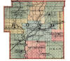
- 1 Township Plats of Bond. County (volume of maps of surveyors), p. 1, in the office of the circuit clerk, Greenville, Illinois, A reproduction of this map in reduced form appears infra, p. 2.
- 2 John Nowlan, "C.W.A. Engineer Report on Tamalco Township," Greenville Advocate, Apr. 2, 1934.
- 3 Henry H. Smith, In Membership Narratives of the Old Settlers' Association of Bond County, Illinois, MSS in possession of John Nowlan, Greenville, Illinois (hereinafter referred to as O.S. Narratives).
- 4 Nowlan, Greenville Advocate, Apr. 2, 1934.
- 5 Township Plate of Bond County, p. 1.
- 7 Joe1 R. Smith, O.S. Narratives.
- 8 Joseph H. Donnell, ibid.
- 9 Henry E. Smith, ibid.
- 10 Charles Colby, Handbook of Illinois (New York, 1854), p. 26.
- 11 Charles B. Johnson, Illinois in the Fifties (Champaign, Illinois, 1918), p. 110.
- 12 Ibid
- 13 Field Notes, I, 156.
- 14 Joseph M. Donnell, O.S. Narratives.
- 15 Township Plats of Bond County, p. 1.
- 16 Warner and. Beers, Atlas of Bond County and the State of Illinois (Chicago, 1875), p. 5.
- 17 TownShip Plats of Bond County, p. 1. See reproduction supra, p. 2.
- 20 Field Notes, I, 83, 110, 115, 142, 173, 344; II, 3, 5, 23, 56, 83.
- 21 Warner and Beers, op. Cit. p. 5.
- 22 Nowlan, Greenville Advocate, Apr. 2, 1934.
- 23 Appraisement bill, estate of William Nelson, July 10, 1841, Record 3-2 (probate record, 1837-44), p. 216, in the office or the county clerk, Greenville, Illinois.
- 24 McCracken, 0.S. Narratives.
- 25 Judge S. A. Phelps, "Greenville in the Forties," in W. C. Carson, (ed.)Historical Souvenir of Greenville, Illinois Effingham, Illinois, 1905), p. 22 hereinafter referred to as Hist.Souv.).
- 26 Johnson, op. cit., pp. 110-11.
- 27 John Buchanan, Life Record, Ills in possession of Jobn Nowlan, Greenville, Illinois.
- 28 Nowlan, Greenville Advocate, Apr. 2, 1934.
- 29 Nowlan, Greenville Advocate, Apr. 16, 1934.
- 30 William Henry Perrin, History of Bond and Montgomery Counties, Illinois (Chicago, 1884), p. 19.
- 31 Nancy Redfearn, 0.5. Narratives.
- 32 James Jackson Matthews, ibid
- 33 Inventory, estate of J W. Holbrook, Sept. 6, 1847, Record E-5 (probate record, 1846-48), p. 61, in the office of the County clerk, Greenville, Illinois.
- 34 Johnson, op. cit., pp. 76-77.
- 35 Record Book A-I (probate record, 1821-38), in the office of the county clerk, Greenville, Illinois.
- 36 Perrin op. cit., p. 40.
- 37 Joel R. Smith, 0.3. Narratives.
- 38 County Record (proceedings of the County Commissioners' Court, 1317-39), p. 7, session of Aug. 2, 1817, in the office of the Circuit clerk and recorder, Greenville, Illinois.
- 39 Ibid,, p. 17, session of July 20, 1313.
- 40 House Journal, Illinois (Kaskaskia, Illinois, 1819), 1st session, 1819, p. 121.
- 41 Johnson, op. cit., p. 112.
- 42 Willian Gray McCaslin, 0.5. Narratives.
- 43 James Dolan,. ibid.
- 44 John Nowlan, "Prehistoric Indian Works," Pocahontas News-Patriot, Oct. 5, 1934.
- 45 Ibid
- 46 Payson Jackson Treat, The National Land System, 1785-1820 (New York, 1910), p. 164.
- 47 Mrs, Elizabeth Harbour, 0.5. Narratives.
- 48 Perrin, op. cit., p. 14.
- 49 John M. Peck, "Annals of the West (1815)," extract in Journal of the Illinois State Historical Society, XVII (Jan.,1925), 741-42 (hereinafter referred to as JISHS).
- 50 Ibid.
- 51 Perrin, op. cit., p. 19.
- 52 Al1en Taylor, 0.5. Narratives.
- 53 Hiram Reavis, ibid.
- 54 Field Notes, I, 46.
- 55 Daughters of 1812 Honor Memory of Thomas Higgins, Famous Indian Fighter ," JISHS, XVII (Jan., 1925),740-41.
- 56 Field Notes, I, 153.
- 57 Ibid., p. 115. -
- 58 lbid., p. 344..
- 60 Treat, op. cit., pp. 120, 169.
- 61 Original Entry Book, Bond County, p. 70 (hereinafter referred to as O.E. Book), in the office of the circuit clerk and recorder, Greenville, Illinois.
- 62 General Public Acts of Congress Respecting the Sale and Disposition of the Public Lands (Washington, 1833), I, 277 [hereinafter referred to as Public Land Laws).
- 63 James McGillispie, 0.S. narratives.
- 64 Public Land Laws, I, 225-26.
- 65 A J. Strange, "John Tillson" JISHS XVII (Jan., 1925), 716-17.
- 66 Edward J. Hughes, Secretary of State, Counties of Illinois (Springfield, 1934), pp. 26-27.
- 67 Ibid., PP. 15-25.
- 68 Ibid 34-35.
- 69 County Record, pp. 1-2.
- 70 Ezekiei Enloe, 0.S. Narratives.
- 71 County Record., p. 21.
- 72 John Nowlan, "The Long Family," Greenville Advocate, June 7, 1834. Mr. Nowlan in writing this and other family sketches had access to the records of the families concerned.
- 73 O.E. Book, p. 147.
- 74 Nowlan, "The Johnson Family," Pocahontas News-Patriot Dec. 14, 1935.
- 75 Thonas Wood, 0.5. Narratives. The writer has used family records and the diary of his father, William Wood.
- 76 O. S. Narratives, particularly records of John Henry Taylor, Elisha Pain, Jeremiah Coyle, Mrs. C. Klasters, Noah Sugg, George Neathery, Joel R. Smith, Elizabeth Wafer Hynes, William Avery Snow, and Jonatban Kesler.
- 77 Mrs. E. S. Walker, "Soldiers of the American Revolution Buried in Illinois," JISHS, VII (Oct., 1914), 197-26; "Revolutionary Soldiers in Bond County," Sorento News, April 26, 1934.
- 78 Buchanan, Life Record.
- 79 Rev. Lemuel Foster, "Journal of a Pioneer Missionary," JISHS, xxi (July, 1928), 195-96.
- 80 Will of John Wesley Strade, Record Book A-i, p. 37, Aug. 18, 1823.
- 81 Carson, Hist. Souv., p. 52.
- 82 Will of John Laughlin, Record Bock A-1, p. 71, May 20, 1821.
- 83 Nancy Jane Leaverton Sale, "Illinois Descendants of Edward Smith," JISHS XI (July, 1918), 400-01.
- 84 Lucy Davis Davis, 0.S. Narratives.
- 85 Eviline J. Coburn, ibid-
- 86 Will of Joseph Howell, Record Bock A-1, pp. 198-200, Aug. 7, 1833
- 87 Will of Thomas White, Record Book A-1, pp. 51-53, Dec. 6 1823,
- 88 Appraisal, estate of David Mills, Record Book A-1, pp. 249-250, Sept. 23, 1834; appraisal, estate of Pleasant Jones, Record Book E-5, pp. 113-14, Jan.5, 1347.
- 89 Appraisal, estate of David Mills, Record Book A-1, pp. 249~250, Sept. 23, 1834.
- 90 Sale bill, estate of William Blizzard, Record Book A-1, PP. 312-13, Oct. 10, 1835.
- 91 Appraisal, estate of Isaac Williams, Record Book A-1, PP. 2~4, Dec. 5, 1834.
- 92 Ibid.
- 93 Inventory, estate of Henry Williams, Record book E-5 P.173, May 12, 1848.
- 94 Appraisal, estate of Jesse McAdams, Record book E-5 P.201-202 May 5 1848
- 95 Sale Bill, estate of David H Mills, Record book A-1, P.252 Oct. 15, 1834.
- 96 Ibid. p. 254.
- 97 Sale bill, estate of James McClung, Record book B-2 P 255, Nov. 23,.1841
- 98 Inventory, estate of Sarah Rowland, Record book E-5 P 72, Sept. 5, 1847.
- 99 Appraisal, estate of William Nelson, Record book B-2 P.201, Apr. 24, 1841.
- 100 Nancy Redfearn, 0.S. Narratives.
- 101 Compendium of the Enumeration of the Inhabitants and Statistics of the United States as obtained at the Department of state from the Returns of the Sixth Census, by Counties and principal Towns Washington, 1842), pp. 300-01.
- 102 Sale bill, estate of David H. Mills, Record Book A-l, P. 250, Oct. 15, 1834.
- 103 Will of John Laughlin, Record Book A-1, pp. 73-76, May 20, 1821.
- 104 Will of Thomas White, Record Book A-1, pp. 51-53, Dcc. 3, 1823.
- 105 Will of Joseph Howell, Record Book A-1, pp. 198-200, Aug. 7, 1833.
- 106 Will of Aquilla Sugg, Record Book A-l, pp. 167-69, March 4, 1333.
- 107 Will of Henry File, Record Book A-I, pp. 343-46, June 26, 1836
- 108 Record A (Circuit Court, 1821-40), p. 341, session of May 25, 1839, in the office of the circuit clerk and recorder, Greenville, Illinois
- 109 County Record, p. 23, July 20, 1818.
- 110 House Journal, Illinois, 1st session, 1819 (Kaskaskia, 1819), p. 180; Senate Journal, Illinois, 1st session, 1819 Kaskaskia, 1819, p. 204.
- 111 County Record, pp. 144-45, Oct. 5, 1817.
- 112 Collections of the Illinois State Historical Library (Springfield 1935), XXVI, 55
- 113 Will of Hardy Vollentine, Record Book A-1, pp. 20-23 Jan 5 1822
- 114 E. B. Washburn, Sketch of Edward Coles Second Governor of Illinois and of the Slavery Struggle of 1823-4 (Chicago, 1882), reprinted in C. W. Alvord (ed.); Collections of the Illinois State Historical Library, XV (Springfield, 1918), 68-82, 94.
- 115 Ibid., pp. 93-94
- 116 Ibid., pp. 83-84.
- 117 Foster, JISHS, XXI (July, 1928), 195-96.
- 118 Compendium, op. cit., p. 86.
- 119 Phelps, in Hist. Souv., pp. 20-21.
- 120 Harry T. Stokes, "Protestantism in Illinois before 1835," JISHS XII (Apr., 1919), 24-30. A letter of Albert Hale, early Baptist preacher of Bond County, is quoted.
- 121 Foster, JISHS, XXI (July, 1928), 196.
