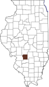


Border Changes
04 Jan 1817
BOND created by Illinois Territory from MADISON; BOND included
territory in present Illinois, Wisconsin, and Michigan. (Ill.
Terr. Laws, 254-256)
03 Dec 1818
BOND lost all territory in present Michigan and Wisconsin to Michigan
Territory when the state of Illinois was created from Illinois Territory;
BOND became a county in the state of Illinois. (Terr. Papers U.S., 10:803;
U.S. Stat., vol. 3, ch. 67 [1818], secs. 1-2, 7/pp. 428-429, 431, and res. 1
[1818]/p. 536)
30 Jan 1821
BOND lost to creation of SANGAMON. (Ill. Laws 1820-1821, pp. 45-46)
31 Jan 1821
BOND lost to creation of PIKE. (Ill. Laws 1820-1821, p. 59)
12 Feb 1821
BOND lost to creation of MONTGOMERY. (Ill. Laws 1820-1821, pp. 142-143)
14 Feb 1821
BOND lost to creation of FAYETTE. (Ill. Laws 1820-1821, pp. 164-167)
27 Dec 1824
BOND lost to creation of CLINTON. (Ill. Laws 1824-1825, pp. 27-30)
19 Feb 1841
Legislature authorized BOND to gain from MADISON the eastern halves of
townships 4 to 6 north, range 5 west, dependent on local referendum that
failed [no change]. (Ill. Laws 1840-1841, p. 80)
02 Mar 1843
BOND gained from MADISON. (Ill. Laws 1842-1843, pp. 98-99)
Source: Illinois Atlas of Historical County Boundaries
