


Places
| PLACE | CURR vs HIST | * | PRECINCT | TOWNSHIP | NOTES |
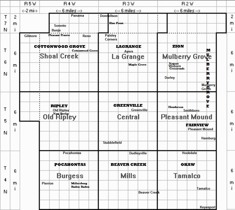
| Amity | historic | v | Pocahontas | Burgess | now known as Pocahontas |
| Ayers | current | n | LaGrange | LaGrange | northwest of Greenville |
| Baden Baden | historic | PO | Pocahontas | Burgess | in Millersburg |
| Beaver Creek | current | n | Beaver Creek | Mills | |
| Beaver Creek | historic | p | Beaver Creek | Mills | included Dudleyville and Beaver Creek |
| Bethel | - | - | Cottonwood Grove | Shoal Creek | campground first now cemetery |
| Bucktown | historic | v | Mulberry Grove | Mulberry Grove | now known as Mulberry Grove |
| Bunje | current | n | Cottonwood Grove | Shoal Creek | Sorento |
| Burgess | current | t | Pocahontas | Burgess | includes Pierron |
| Central | current | t | Greenville | Central | |
| Cottonwood Grove | historic | s | Cottonwood Grove | Shoal Creek | |
| Cottonwood Grove | historic | p | Cottonwood Grove | Shoal Creek | included Cottonwood Grove, Elm Point, and Pleasant Prairie |
| Donnellson | current | v | Cottonwood Grove | Lagrange vs Shoal Creek | formerly known as Bear Creek, part in Montgomery county |
| Dudleyville | current | n | Beaver Creek | Mills | southwest of Greenville Airport |
| Durley | current | n | Zion | Mulberry Grove | near Governor Bond Lake |
| Elizabeth City | historic | - | Greenville | Central | a paper city 3 miles west of Greenville |
| Elm Point | historic | n | Cottonwood Grove | Lagrange / Shoal Creek | just south of Donnellson |
| Fairview | historic | t | Fairview | Pleasant Mound | 8 miles east of Greenville |
| Fairview | historic | v | Fairview | Pleasant Mound | included Fairview and Pleasant Mound PO |
| Gilmore | current | n | Cottonwood Grove | Shoal Creek | southwest of Sorento |
| Greenville | current | c | Greenville | Central | included New Jerusalem, Piety Hill, Cobtown, and Buzzard Roost neighborhoods |
| Greenville | historic | p | Greenville | Central | included Greenville, Henderson, and Stubblefield |
| Hamburg | current | n | Fairview | Pleasant Mound | also known as New Hamburg |
| Henderson Station | historic | n | Greenville | Central | included Smithboro PO |
| Hickory Grove | historic | v | Pocahontas | Burgess | now known as Pocahontas |
| Hookdale | current | n | Okaw | Tamalco | southeast of Greenville |
| Houston | historic | v | Mulberry Grove | Mulberry Grove | now known as Mulberry Grove |
| Keyesport | current | v | Okaw | Tamalco | sw corner of Bond, part in Clinton county |
| Lagrange | current | t | Lagrange | Lagrange | includes Ayers and Paisley Corners |
| Lagrange | historic | p | Lagrange | Lagrange | |
| Maple Grove | historic | n | Lagrange | Lagrange | |
| Millersburg | historic | n | Pocahontas | Burgess | included Baden Baden PO |
| Mills | current | t | Beaver Creek | Mills | includes Dudleyville |
| Mulberry Grove | current | v | Mulberry Grove | Mulberry Grove | formerly known as Bucktown, Houston, and Shakerag |
| Mulberry Grove | historic | p | Mulberry Grove | Mulberry Grove | |
| Mulberry Grove | current | t | Mulberry Grove | Mulberry Grove | |
| Neport | historic | v | Zion | Mulberry Grove | aka Newport |
| New Berlin | historic | v | Ripley | Old Ripley | |
| Okaw | historic | p | Tamalco | ||
| Old Ripley | current | v | Ripley | Old Ripley | formerly known as New Berlin and Ripley |
| Old Ripley | historic | PO | Ripley | Old Ripley | |
| Old Ripley | current | t | Ripley | Old Ripley | |
| Paisley Corners | current | n | Lagrange | Lagrange | on Route 127 nw of Greenville |
| Panama | current | v | Cottonwood Grove | Shoal Creek | part in Montgomery county |
| Pierron | current | v | Pocahontas | Burgess | was half in Madison county |
| Pleasant Mound | historic | PO | Fairview | Pleasant Mound | |
| Pleasant Mound | current | n | Fairview | Pleasant Mound | ssw of Mulberry Grove, ese of Greenville |
| Pleasant Mound | current | t | Fairview | Pleasant Mound | |
| Pleasant Prairie | historic | Cottonwood Grove | Shoal Creek | included Harrisonville | |
| Pocahontas | current | v | Pocahontas | Burgess | formerly known as Hickory Grove, Amity, and Pocohontas |
| Pocahontas | historic | p | Pocahontas | Burgess | included Baden Baden PO, Pocahontas, and Millersburg |
| Reno | current | n | Cottonwood Grove | Shoal Creek | southeast of Sorento along railroad line |
| Ripley | historic | p | Ripley | Old Ripley | included Old Ripley PO and New Berlin |
| Shakerag | historic | v | Mulberry Grove | Mulberry Grove | now known as Mulberry Grove |
| Shoal Creek | current | t | Cottonwood Grove | Shoal Creek | |
| Smithboro | current | v | Greenville | Pleasant Mound | at Henderson Station, also Smithborough |
| Sorento | current | v | Cottonwood Grove | Shoal Creek | |
| Stubblefield | current | n | Greenville | Central | station 4 miles west of Greenville |
| Tamalco | current | n | Okaw | Tamalco | northwest of Keyesport along railroad line |
| Tamalco | current | t | Okaw | Tamalco | |
| Woburn | historic | PO | Zion | Mulberry Grove | |
| Woburn | current | v | Zion | Mulberry Grove | formerly known as Crossroads and Neport |
| Zion | historic | p | Zion | Mulberry Grove | included Neport |
* p = PRECINCT
t = TOWNSHIP
PO = POST OFFICE
s = SETTLEMENT
n = NEIGHBORHOOD
v = VILLAGE
c = CITY
Cannot find your place name? Maybe it was in Bond County years ago, but you’ll find it in another county today.
Bond was created 04 Jan 1817 in Illinois territory out of Madison county; Bond included territory in present Illinois, Wisconsin, and Michigan. Bond lost all territory in present Michigan and Wisconsin to Michigan Territory when the state of Illinois was created from Illinois territory 03 Dec 1818; Bond became a county in the state of Illinois.
Five counties were carved out of Bond county
- Sangamon county, 30 Jan 1821
- Pike county, 31 Jan 1821
- Montgomery county, 12 Feb 1821
- Fayette county, 14 Feb 1821
- Clinton county, 27 Dec 1824
Legislature authorized Bond county to gain from Madison county the eastern halves of townships 4 to 6 north, range 5 west, dependent on local referendum that failed 19 Feb 1841 (no change). Bond did gain from Madison county 02 Mar 1843.
